


وصف لـ WinGPS™ Marine
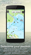
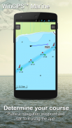
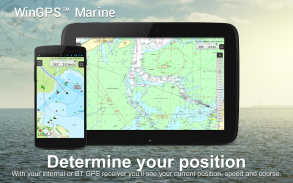
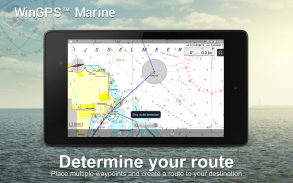
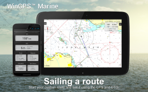
WinGPS Marine offers you modern, easy to learn navigational tools for a safe trip. Long press on the chart to plot your route. The GPS on board will show your exact location. Download the charts to your device and go boating offline with the most up-to-date charts. Connect your AIS via WIFI and prevent possible collisions.
Developed by Stentec for navigation on sailing and motor yachts, sloops and canoes at sea, tidal and inland waters. Ideal when renting or chartering a boat.
NEW [2017]
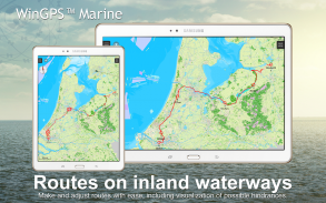
• Support for the waterways for the inland charts Western Europe and Donau with bridge-, locks and waterway information. With this you can plot and adjust your routes quickly, indicating any obstacles. The names of the waterways and distances will be shown during your trip.
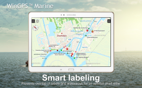
• Smart labeling prevents overlapping text labels (with waterways also) for an optimal chart image. Bridge and lock data will always be readable on Course Up rotating charts.
HIGHLIGHTS
• Navigating on up-to-date charts of Stentec, Imray, NOAA and Delius Klasing.
• SD-card support for chart storage.
• Manage tracks, charts, routes and waypoints.
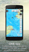
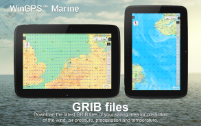
• NOAA World GRIB-files: wind, air pressure, rainfall and temperature.
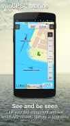
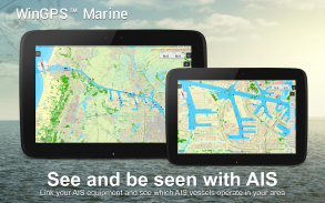
• Connect AIS and GPS via wirelesss WIFI or Bluetooth connection.
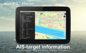
• Prevent collisions with the speed vectors of the AIS ships.
• Man-overboard button helps to retrieve lost crewmembers.
• Chart moves along underneath centered GPS position. NorthUp, CourseUp (Marine) or HeadUp (Plus).
• Harmoniemodel KNMI with detailed weather predictions (Plus, Netherlands only)
• NOAA wave prediction at open sea (Plus, Worldwide)
When WinGPS Marine is installed for the first time, this will be WinGPS Marine Lite with limited functions. Ideal as a chart viewer with GPS support.
IN-APP PURCHASE
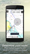
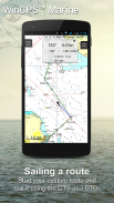
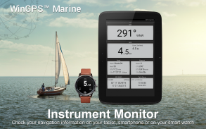
After putchasing WinGPS Marine, you will unlock the full capabilities of your personal navigation system. You are now able to plot routes, download GRIB files, save previous tracks and connect AIS and GPS. Use the handy time table to view the predicted wind, rain, air pressure and AIS targets.
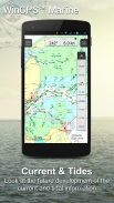
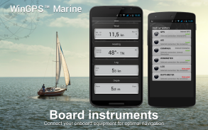
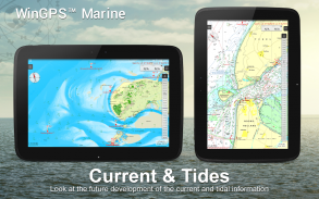
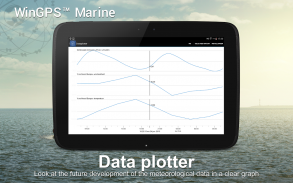
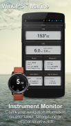
With the WinGPS Marine Plus upgrade, you will be able to connect additional board instruments via wireless connection to you board PC, multiplexer or AIS transponder. You can display current and tidal information in your data plotter or view it on the chart. Also, the advanced KNMI’s Harmonie weather model is supported as well as the NOAA waves worldwide.
KUSTFIJN Getijmodel Rijkswaterstaat with two day wind depended predictions of currents, tides and water levels on the Waddenzee, Ijsselmeer, Markermeer, Randmeren and Zeeland. Red depth lines limit the safe waterways depending on depth, tides and deviations because of the wind.
CHART COVERAGE & INSTALLING THE CHARTS
When you start WinGPS Marine you will automatically see the (online) topographic default chart of ESRI. You can also turn on the NOAA charts of the US and download the free world chart via the Chart Manager
For safe navigation, you can purchase digital charts at www.stentec.com. It’s also possible to purchase the charts in the app or via Google Play™. Your charts can be installed on 3 different devices. For example, on your Android tablet, phone and Windows laptop or computer.
Log in with your Stentec Account in the Marine app and download or update your purchased DKW2 charts in the Chart Manager.
For example, the popular DKW1800 series with weekly BaZ updates and the NL Chart with biweekly updates. Our online shop offers up-to-date sea charts and all inland charts of Western Europa including the Donau.
With the DKW Builder (optionally), you can use scanned or BSB charts to build your own DKW2 chart set. The new DKW2 charts can be copied to the DKW2 folder on your tablet via a USB cable to use the charts in WinGPS Marine.
More information: www.wingpsmarine.com
USERS INPUT
For improvement of the app we are very much interested in your experience and suggestions. Please send an e-mail to helpdesk@stentec.com.
تقدم WinGPS البحرية التي حديثة وسهلة التعلم الأدوات الملاحية لرحلة آمنة. الضغط لفترة طويلة على الرسم البياني لمؤامرة مسارك. سوف GPS على متن تظهر موقعك بالضبط. تحميل الخرائط على جهازك ويذهب القوارب حاليا مع معظم المخططات يصل إلى التاريخ. ربط AIS عبر WIFI ومنع الاصطدامات المحتملة.
التي وضعتها Stentec للملاحة على الإبحار والحركية اليخوت والسفن الشراعية والزوارق في المياه البحرية والمد والجزر والداخلية. مثالية عند تأجير أو استئجار قارب.
NEW [2017]
• دعم الممرات المائية للحصول على المخططات الداخلية أوروبا الغربية ودوناو مع الماضي-، والأقفال والمعلومات الممر المائي. مع هذا يمكنك رسم وضبط الطرق الخاصة بك بسرعة، مما يشير إلى أي عقبات. وسيتم عرض أسماء الممرات المائية والمسافات أثناء رحلتك.
• وضع العلامات الذكية يمنع التسميات النصية المتداخلة (مع الممرات المائية أيضا) للحصول على صورة المخطط الأمثل. سوف البيانات الجسر وقفل تكون دائما قابلة للقراءة على ملعب يصل المخططات الدورية.
يسلط الضوء
• التنقل على ما يصل إلى تاريخ الخرائط من Stentec، Imray، NOAA ودليوس Klasing.
• دعم SD بطاقة لتخزين الرسم البياني.
• إدارة المسارات، والرسوم البيانية، والطرق ونقاط الطرق.
• GRIB ملفات NOAA العالمي: الرياح والضغط الجوي والأمطار ودرجة الحرارة.
• توصيل AIS وGPS عبر WIFI wirelesss أو اتصال Bluetooth.
• منع التصادم مع نواقل سرعة السفن AIS.
• زر مان البحر يساعد على استرداد افراد الطاقم المفقودة.
• خطوات الرسم البياني على موقف GPS تركز تحتها. نورثوب، CourseUp (البحرية) أو HeadUp (زائد).
• Harmoniemodel KNMI مع التنبؤات الجوية مفصلة (زائد، هولندا فقط)
• التنبؤ موجة NOAA في البحر المفتوح (بالاضافة الى ذلك، في جميع أنحاء العالم)
عند تثبيت WinGPS البحرية لأول مرة، وسيكون هذا WinGPS البحرية لايت مع وظائف محدودة. مثالية كمشاهد الرسم البياني مع دعم GPS.
IN-APP شراء
بعد putchasing WinGPS البحرية، سوف تطلق العنان للقدرات كاملة لنظام الملاحة الشخصي. أنت الآن قادرا على رسم الطرق، وتحميل الملفات GRIB، حفظ المسارات السابقة والاتصال AIS وGPS. استخدام جدول زمني مفيد لعرض توقع الرياح والمطر، والضغط الجوي وأهداف AIS.
مع الترقية WinGPS البحرية بالاضافة الى ذلك، سوف تكون قادرا على الاتصال الصكوك مجلس إضافية عبر اتصال لاسلكي كنت متن PC، المضاعف أو AIS مستجيب. يمكنك عرض المعلومات الحالية والمد والجزر في الراسمة البيانات الخاصة بك أو مشاهدته على الرسم البياني. أيضا، يتم اعتماد نموذج الطقس هرموني في KNMI المتقدمة، فضلا عن موجات NOAA في جميع أنحاء العالم.
KUSTFIJN Getijmodel Rijkswaterstaat مع يومين الرياح تعتمد تنبؤات التيارات، والمد والجزر ومستويات المياه على Waddenzee، بحيرة آيسل، Markermeer، Randmeren و زيلاند. خطوط حمراء عمق تحد من الممرات المائية آمنة اعتمادا على العمق، والمد والجزر وانحرافات بسبب الرياح.
CHART التغطية وتركيب الرسم البياني
عند بدء تشغيل WinGPS البحرية سترى تلقائيا (على الانترنت) الرسم البياني الطبوغرافية الافتراضي ESRI. يمكنك أيضا تشغيل المخططات NOAA من الولايات المتحدة وتحميل الرسم البياني العالم الحر عبر مدير التخطيط
لسلامة الملاحة، يمكنك شراء الخرائط الرقمية في www.stentec.com. ومن الممكن أيضا لشراء المخططات في التطبيق أو عبر في Google Play ™. يمكن تثبيت الخرائط الخاصة بك على 3 أجهزة مختلفة. على سبيل المثال، على جهاز الروبوت اللوحي والهاتف ويندوز الكمبيوتر المحمول أو الكمبيوتر.
تسجيل الدخول باستخدام حساب Stentec الخاص في تطبيق البحرية وتحميل أو تحديث الخرائط الخاصة بك DKW2 شراؤها في إدارة تخطيط.
على سبيل المثال، سلسلة DKW1800 شعبية مع التحديثات باز الأسبوعية والرسم البياني NL مع تحديثات كل أسبوعين. يقدم متجر على الانترنت ما يصل إلى تاريخ الخرائط البحرية وجميع الخرائط الداخلية من أوروبا الغربية بما في ذلك دوناو.
مع DKW باني (اختياريا)، يمكنك استخدام الخرائط الممسوحة ضوئيا أو BSB لبناء الخاصة بك DKW2 الرسم البياني مجموعة. يمكن نسخ الخرائط DKW2 جديدة إلى المجلد DKW2 على جهازك اللوحي عن طريق كابل USB لاستخدام الرسوم البيانية في WinGPS البحرية.
مزيد من المعلومات: www.wingpsmarine.com
المستخدمين INPUT
لتحسين التطبيق نحن جدا مهتم كثيرا في الخبرة واقتراحاتكم. يرجى ارسال رسالة على البريد الإلكتروني للhelpdesk@stentec.com.

WinGPS™ Marine - معلومات APK
نُسخة APK: 4.60الحزمة: com.stentec.wingps_marine_liteتطبيقات من الفئة نفسها
قد يعجبك أيضًا...


